The Tambov Region is one of the main regions of the Russian Black Earth Region. On its territory there are 193 rivers with a length of more than 10 km, and 8 rivers with a length of more than 100 km. The region is located at the watershed of the Volga and Don basins. All rivers belong to small rivers, there is no navigation on them. The only exception is the Tsna River, which is used for regional transportation.
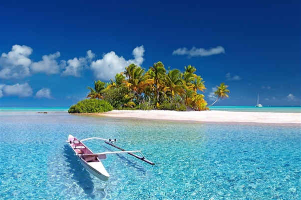
The largest waterway in the region is Tsna, and the Vorona River is considered the most beautiful. The most famous is, of course, Voronezh, for the Azov campaigns of Peter I. The valleys of many rivers pass through picturesque forests, there are rivers in the steppe zone, on open spacious plains. Travelers come here for fishing, river rafting, and just for beautiful views.
The longest rivers in the Tambov region
List of the largest rivers flowing through the region.
Crow
The right tributary of the Khopra flows through the territory of the Voronezh, Penza and Tambov regions. On Vorona there are the large Tambov cities of Uvarovo and Kirsanov. It is rightfully considered one of the most beautiful rivers in the region: coastal terraces, a steep right bank, gentle left-sided slopes are covered with forest: oak forests, willow and alder forests. Under Peter I, ship timber was rafted here. Voroninsky Nature Reserve was formed on the river near the town of Kirsanov.
The length of the river is 454 km, in the Tambov region - 234 km.

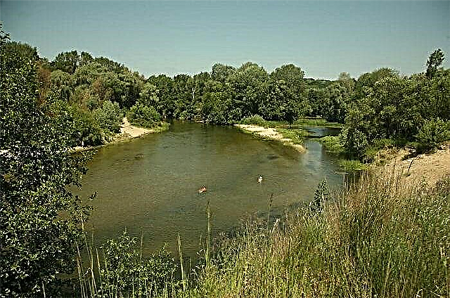
Tsna
The source of this river is in the Tambov region, at the confluence of small rivers. It receives 15 main tributaries along its entire length. It has a calm current, heavily regulated by dams. After Tambov, the channel winds strongly, flows along a wide plain, with swamps and oxbows. 47 km of the total length are navigable. Near the village of Ustye, Ryazan Region, Tsna flows into the Moksha River.
The total length of the river is 451 km.

Bityug
The river passes through three regions at once: Tambov, Lipetsk and Voronezh regions. In the Tambov region, in the vicinity of the village of Petrovskoe, Tokarevsky district, there is the source and upper course of the river, and the main part of the river bed is in the Voronezh region, where these places are loved by fishermen and lovers of forest hikes. The beginning of Bityug runs along a narrow valley, 1 - 3 meters wide, dissected by ravines and ravines.
The length of the river is 379 km, in the Tambov region - 99 km.

Voronezh
The left tributary of the Don connects three regions: Tambov, Lipetsk and Voronezh regions. Formed in the Tambov region, at the junction of Polny and Lesnoy Voronezh, near the village of Novonikolskoye. It flows through a narrow terraced valley. Oak and pine forests grow along the steeper, higher right bank. Before the border with the Voronezh region, the river receives several small tributaries, along its banks are the villages of Staroye and Novoye Torbeevo, Kazinka, Yarok.
The length of the river is 342 km, in the Tambov region - 22 km.

Savala
The source of this river is in the vicinity of the village of Novoaleksandrovka, Tambov region, and the mouth is already in Voronezh, where it flows into Khoper. The Burnachka River flows into Savala near the village of Burnak. In the vicinity of the village of Vyazovoye, an ancient dam, one meter high, 20 meters wide, has been preserved. It is called the local waterfall. The river is famous for its abundance of fish, as well as for the fact that the Saval Forest has been preserved along its banks. This is an artificial plantation, which began in 1875.
The length of the river is 285 km, in the Tambov region - 119 km.

Couple
One of the many tributaries of the Oka flows mainly in the Ryazan region. And only the source and the first few kilometers of the channel are located in Tambov. The pair originates from the village of Novocherkasovka. Well suited for kayaking and travel in spring and the first weeks of summer. Fishermen celebrate good fishing here, the current is calm.
The total length of the river is 192 km.

Matyr
The left channel of Voronezh flows in Lipetsk and Tambov regions. It starts near the village of Bolshaya Matyra, at the beginning of the path it is a weak water stream. After the confluence of the Plavica River, it increases significantly. The current is not strong, the banks are little covered with forest. Many events in the ancient history of these places are associated with this name: at least 40 historical monuments of different eras have been found here.
The length of the river is 180 km, in the Tambov region - 120 km.

Complete Voronezh
The left source of Voronezh, originates at the very border with the Ryazan region, near the village of Golovnino. It passes through three districts of the Tambov region, there are several villages on the banks. The average depth is about 1 - 3 meters, in some places it reaches 6 - 7 meters, the channel is gradually overgrown with reeds and sedge. Gentle banks alternate with high slopes, up to 25 meters. There are many ponds in the river valley.
The length of the river is 178 km.

Elan
In the Tambov region, only the upper course of this river, which is also called Bolshaya Elan, passes. The source is located in the Zherdevsky district. It flows from north to south, past the villages of Pichevo, Pitim, Lipovka. The nature of the current is calm, the banks are gentle, the channel runs along a meadow valley. In the Voronezh region, Bolshaya Elan is connected with Malaya Elan, forming Elan - a tributary of the Savala.
The length of the river is 165 km, in the Tambov region - 15 km.

Forest Voronezh
The right source of the Voronezh River originates in the Ryazan Region, and in the Michurinsky District in the Tambov Region it connects with Polny Voronezh. The channel is regulated by several dams, passes through a wooded area, the valley is densely populated. Forest Voronezh receives 8 small tributaries, there are many lakes and ponds in the valley. The largest city on the river is Michurinsk; there are also more than 120 small settlements along the banks.
The total length of the river is 164 km.

Tokay
In the local dialect, this river is often called the Tokayka. It begins in the Tambov region northeast of the village of Poletaevo. The estuary is already on the Voronezh land, where it flows into Elan. The current is calm, the river passes through a wide meadow valley. Over time, many tributaries disappeared, the springs flooded, in summer the channel dries up in places.
The total length of the river is 131 km.

Chelnova
The left tributary of the Tsna, the entire length of the river is located on the territory of the Tambov region. It starts from the gully in the Tambov region, then passes through the Sosnovsky and Morshansky districts. It has a narrow, very winding channel; there are many settlements along the banks. Near the village of Sosnovka, the direction of the current sharply changes from north to east. Before the mouth, the channel widens to 40 - 60 meters.
The length of the river is 121 km.

Kashma
The right tributary of the Tsna, originates from the village of Osino-Gai in the Gavrilovsky district. In the upper course it runs along a deep plain with slopes up to 40-50 meters. Closer to the mouth, the valley widens, the shores become flat. Average depth is 2 - 3 meters. It has several tributaries, mainly small rivers and streams. There are many ponds in the valley, and a fish farm has been set up near Morshansk.
The length of the river is 111 km.

Big Lomovis
The left tributary of the Kashma, most of the path flows through a treeless plain, falling into the forest zone closer to the mouth. The source is located near the village of Novgorodovka. The banks are high, steep, steep. The average width of the channel is 12 - 15 meters, the depth is from 7 meters to 0.5 - 1 meter on the rifts. On the banks of the river there is an old village of the same name. On the right side, it receives a tributary Maly Lomovis, near the village of Kvashnino in the Pechaevsky district.
The length of the river is 106 km.

Stanny Cassock
The river is located in three regions. It originates in the Tambov region, near the village of Elizavetino, Staroyuryevsky district. The middle course runs through the Ryazan region. And the mouth is in Lipetsk, where Stanovaya Ryasa flows into Voronezh along the right bank. Thus, in the Tambov region there are only the first kilometers of the Stanovoy Ryasy channel. It takes five small tributaries all the way.
The total length of the river is 100 km.

Karachan
This river is also called Wet Karachan.Among its few tributaries there is also the Sukhoi Karachan River, which has a more modest size. It originates from the village of Demyan Bedny in the Tambov region, and the mouth is in the Voronezh region, where it flows into the Khoper along the right bank. The slopes of the river are open, covered with grassy vegetation or shrubs. The water is considered one of the cleanest in the Black Earth Region.
The total length of the river is 95 km.

Ertil
The tributary of the Bityug River flows through two Russian regions. The source is located on the territory of the Tambov region, southeast of the village of Tokarevka, then passes by Znamenka and Aleksandrovka. Then it moves to the territory of the Voronezh region. It is divided into the Big Ertil, in the upper reaches, which, connecting with the Small Ertil, gives rise to the main channel.
The length of the river is 92 km, in the Tambov region - 34 km.
Forest Tambov
The right tributary of the Tsna is completely located on the territory of the Tambov region. There are several settlements on the banks, the largest of which is the town of Rasskazovo. The average width of the channel is 50 m. It makes several large loops on its way. 5 km from the city of Kotovsk on the river, there is the Kotovskoe reservoir, about 12 km long and 3 km wide, surrounded by a mixed forest.
The length of the river is 89 km.

Karay
Left tributary of the Vorona River. It originates in the Saratov region. The channel is not wide, from 5 to 10 meters, very meandering, the current is weak. Ravines are often encountered along the right steep bank. It receives two small rivers and a stream. It flows into the Vorona near the village of Karai-Pushchino, in the Inzhavinsky district of the Tambov region.
The total length of the river is 86 km.

Plavitsa
One of the main tributaries of the Matyra, flows into it along the left bank. It originates from the village of Verkhnyaya Plavitsa in the Voronezh region. In the middle reaches, it enters the territory of the Lipetsk region. Only the lower reaches of the river are located in Tambovskaya. Here the channel is quite deep, on average 3-4 meters, the banks are surrounded by deciduous forest. There is a gauging station in the village of Bogoroditskoye.
The length of the river is 87 km, in the Tambov region - 15 km.

Ilovaj
The main part of the length of this river is located in the Tambov region, and only the source and a small section of the upper reaches are in the Ryazan region. It flows into the Voronezh River along the right bank. It receives several small tributaries, the largest is Sukhoi Ilovaj. In the lower course, rapids are formed due to the protrusions of limestone deposits. The valley is deep and narrow here.
The total length of the river is 77 km.
Verda
It flows in the Tambov and Ryazan regions, and in the Tambov there is only a small part of the upper course. It originates in the Staroyuryevsky district, near the village of Bolshaya Verda, near the border of two regions. In the upper reaches, the channel is not wide, closer to the mouth it expands in places up to 30 meters. It takes three main tributaries and flows into the Para River on the left.
The total length of the river is 75 km.

Knitting
Left tributary of the Vorona. It flows through two districts of the Tambov region: Umetsky and Kirsanovsky. The source is located near the village of Glukhovka. The river is so named for its silty, viscous bottom. It flows through a narrow picturesque valley. The channel width is from 7 to 11 meters, the depth is not more than 1 - 2 meters. Knitting is famous for the fact that on its banks, in the village of Mary, the poet Baratynsky was born.
The length of the river is 70 km.

Wet Panda
The river flows in Rasskazovsky, Inzhavinsky and Rzhaksinsky districts of the Tambov region. It flows into the Vorona near the village of Shiryaevka along the left bank. It flows through a deep valley, cut by ravines with numerous streams, for which it got its name. The largest tributaries are the Sukhaya Panda and Lopatinka rivers. The channel width is from 8 to 15 meters, the depth is up to 3 meters.
The length of the river is 69 km.

Small Lomovis
One of the main tributaries of the Bolshoi Lomovis River, flows into it along the right bank near the village of Kvashnino, Pichaevsky District. The main part of the river passes through the Bondarsky district of the Tambov region. On the banks of the river, forest areas are rarely found, there are many gullies, ravines. The largest tributaries are the Black and Rozhka rivers. Along the banks are the villages Trubnikovo, Grazhdanovka, Shilovo, Chernavka.
The length of the river is 66 km.