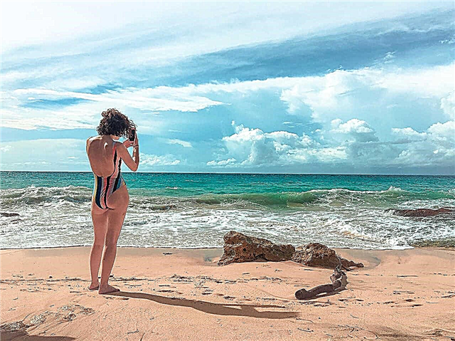
Altai is one of the most unforgettable places in our Motherland. A large number of rivers in the region are suitable for navigation and water tourism at the same time. If in the upper reaches it is a stormy river, with a category for sports competitions in water tourism, then in the lower reaches it can already become calm, flat, passable for ships. Most of the rivers are tributaries of the Ob, one of the largest rivers in Russia.
Altai rivers are striking in their grandeur and uniqueness. Thousands of tourists come to these lands to see the beauty of Altai nature, to undergo medical treatment at resorts, raft down the rivers, catch fish, shoot ducks, ride horses. The total length of all Altai rivers will turn the planet around the equator one and a half times
The longest rivers of the Altai Territory
List, photo with names and descriptions of the largest waterways in the region.
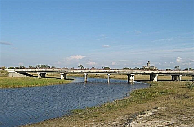
Ob
One of the main waterways of Russia, the Ob, begins at the confluence of the powerful rivers Katun and Biya in the Altai Territory. The river flows not only in the Altai Territory, but also throughout Western Siberia. The Ob is one of the largest navigable rivers. It flows into the Kara Sea in the north. At the mouth of the Ob, the Gulf of Ob was formed.
The length of the river is 3650 km, in the Altai Territory - 493 km

Alei
This is the longest river flowing through the region. It flows into the Ob from the left side downstream. The source of the Alei River is located in East Kazakhstan. Along the banks of the Aley there are two large cities of Aleysk and Rubtsovsk. Two reservoirs on the Alei River provide water to several villages and cities, and serve for irrigation of fields. The river is famous for its regular fishing rod fishing competitions.
River length - 858 km

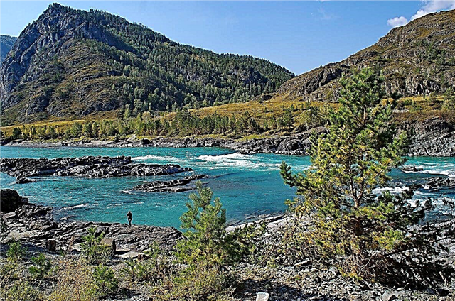
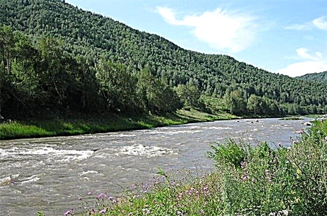
Katun
Katun is formed from melting snow on Mount Belukha, more precisely, on the Gebler glacier. It flows into the Ob near Biysk. There are fifteen rapids on Katun. The most famous: Ilgumensky, Teldekpen, Manzherok attract many thrill-seekers. In addition to the rapids, there are beautiful waterfalls. The water temperature is not higher than 15 degrees. On the banks of the river there is a recreation area: tourist centers, restaurants. In the upper and middle parts, the river flows over sandstones. They give the water such an unforgettable turquoise color.
The total length of the river is 688 km

Chumysh
It feeds the Ob with its waters on the right side downstream. The source of Chumysh is located on the Salair Ridge in the Kemerovo Region. In the upper reaches of the Chumysh, it is rapids. Most of the river runs along the Biysko-Chumysh Upland. Near the mouth, the Chumysh is divided into two branches. The Chumysh estuary is 88 km below Barnaul. On Chumysh, near the village of Zhulanikha, there is a monastic skete (not far from the holy spring).
The total length of the river is 644 km

Charysh
In Altai, it is also called Charas. It originates on the slopes of the Korgon Range in the Altai Republic, it is a left tributary of the Ob. There are rapids along the entire length of the river. And only in the lower reaches the Charysh reaches a wide plain. Fishing on Charysh is famous for its big catch. In 2003, V.V. Putin rafted along the river, was pleased with the beauty of the area and the safety of the rafting. In 2004, a tourist route "Presidential Rafting" appeared.
The total length of the river - 547 km

Burla
The source of the Burla River is located near the village of Dolganka in the Krutikhinsky District. Burla flows along the Kulundinskaya steppe. There are many swamps in the floodplain of the river. In dry years, the river flows into Lake Bolshoye Topolnoye and ends there. In the high water, the river reaches the drainless lake Bolshoy Azhbulat in Kazakhstan. The reservoirs of the Burlin system are of great importance in the fishing industry of the Altai Territory.
The total length of the river is 489 km
Kulunda
It starts from a small swamp near the village of Ust-Mosikha and is fed by melting snow. In 1983, the Kulundinsky Canal was built in the river basin to irrigate fields. Two branches of the river flow into Lake Kulundinskoye. Local residents build their own dams. The river reaches its mouth only during floods. The river banks are picturesque. Water lilies are growing. Ducks nest. Otters live.
River length - 412 km

Anui
It begins in the Ust-Kansk region with two sources: Black and White Anuy. The river flows into the Ob from the left side. Anui's length is 327 km. In the Altai Territory, Anui flows through four districts and is used for timber rafting. In the slope of the mountain above the road from the village of Soloneshnoye to Ust-Kan, a wide entrance opens to the Denisov Cave. It got its name back in the 18th century. An Old Believer hermit lived in the cave.
The length of the river is 327 km, in the Altai Territory - 292 km

Biya
The unique Teletskoye Lake serves as the source of the river. Biya flows into the Ob along the right bank. It is conventionally considered to be the source of the bridge from the village of Artybash to the village of Iogach. Large rapids: Sarykokshinsky, Yurtok, Pyzhinsky, Kebezensky. In the village of Turochak there is the Kipyatok rapids. The last threshold is located in the village of Udalovka. Above this village, on the right bank, on the Iconostasis rock, there is a bas-relief of Lenin - the work of the teacher I. Sychev from Turochak (40s of the XX century). Due to unprofitability, regular shipping along Biya was stopped.
The total length of the river is 301 km

Big river (tributary of the Ob)
The river flows through the plain. It flows into the Ob from the right side. The river begins 10 km from the village of Gornovoe. There are 294 lakes in the Big River basin. The largest of them is Bolshoye Kamyshnoye. In the upper part of the Bolshaya River basin, a network of depressions is observed. The bottom is swampy. From the village of Zagainovo (Verkhneobskoy Bor), the river was used for rafting. In the lower reaches, the river bed is clogged with driftwood.
River length - 285 km

Sandy
The Peschanaya River flows down from the Seminsky ridge, flows through two regions of the Altai Territory: Ongudaysky and Shebalinsky, is a left tributary of the Ob. The estuary is located 35 km from Biysk and is considered a natural monument. There are lakes with nesting places for waterfowl here. The river is the third category for water tourism in the spring and summer. You can walk along it by catamaran or kayak in 8-10 days. After the confluence of the Bolshaya Tikhaya River, the extreme begins. And the parking lot "Vesyolaya" is an open-air museum.
The total length of the river is 276 km
Barnaulka
The Barnaulka River flows out of the Mirror Lake. The length of the river was reduced by forty kilometers due to a deaf earthen dam at the exit from the Serebrennikovskoye lake in the Aleysk region. A road runs along the dam. The city of Barnaul is located at the mouth of the river. The Barnaulka River is a left tributary of the Ob River. Wastewater gets into the river. There is a lot of household waste along the banks. The water at the mouth is dirty.
River length - 207 km

Nenya
The source of the Nenya River is in the mountains of the Kuznetsk Alatau in the Kemerovo Region. The river flows in the Solton district and serves as the right tributary of the Biya river. It is a flat river with a sandy bottom. The Neninsky reserve runs along it. There is a winter swimming club in the village of Karabinka. Every March, a regional championship in memory of KF Degtyarev is held among the "walruses". Steamship cruises take place along the Nenya River.
River length - 185 km

Uksunay
The source of the river is located on the southwestern side of the Salair Ridge. In the upper reaches, the river is stormy, flowing down from the mountains. And in the lower reaches it becomes flat, wide with a calm current. Near the village of Buranovo, Uksunai flows into Charysh and is its right tributary. The places along the river are wild. In the area of the village of Togul, the bridge over Uksunai was destroyed. The passability of roads depends on the amount of precipitation and fallen trees. There are gold deposits in the middle Uksunai.
River length - 165 km

Isha
The Isha River originates in the Chadar mountains of the Sumultinsky ridge of northern Altai at an altitude of 550 m in the Choi region. In the upper reaches, the river runs between the mountains in the western direction, which changes to the northwest after the regional center Choi. In the lower reaches of the Isha it belongs to quiet rivers, the bottom is sandy or pebble with boulders. Isha flows into the Katun near the village of Most-Isha.
The total length of the river - 162 km

Belaya (lower tributary of the Charysh)
The source of the river is on the Razrabotnaya mountain at an altitude of about 2000 meters above sea level in the Goltsov zone of the Tigiretsky ridge.Then it flows through the Zmeinogorsky, Krasnoshchekovsky, Kuryinsky districts and flows into the Charysh River. The river is clean and beautiful, suitable for calm, educational travel.
River length - 157 km

Elk (tributary of the Ob)
The Losikha River begins 35 km from the regional center - Kosikhi, then flows through the Kosikhinsky and Pervomaisky districts and flows into the Ob in the city of Barnaul. The place of confluence is called “Ust-Losikha”. Elk's waters are used for irrigation of agricultural fields. The annual festival of bards "Povalikha" is held a stone's throw from the river in a meadow near the village of Bayunovskiye Klyuchi.
River length - 150 km

Alambay
The sources of the Alambay are in the low mountains of the Salair Ridge. Further, the river flows through the Zarinsky district and flows into the Chumysh on the outskirts of the city of Zarinsk. In the upper reaches, the Alambay is restive, with a fast current, boulders and rifts. In the middle reaches, there are a lot of blockages from the driftwood. In the lower reaches, it is already a calm flat river. There are fish in Alambai: roach, taimen, pike. Beavers, bears, hares, hazel grouses and many other taiga inhabitants live.
River length - 140 km

Chemrovka
The river was formed at the confluence of the rivers: the right Marushka and the left Marushka near the village of the same name (Tselinny district). Chemrovka is a right tributary of the Ob, flows into the Ob downstream of the village of Fominskoye. Zonal district. Lake Utkul is located on the catchment area. The river is home to pike, buffalo and other fish. The river is visited by fishermen, local tourists and from nearby regions.
River length - 123 km

Elbow
The Loktevka river originates at the foot of Mount Sinyukha, the Kolyvansky ridge. In the upper reaches, the river is mountainous. But then the river becomes typically flat, has low banks and a sandy channel. Loktevka is the main river of the Kurinsky district. It flows into Charysh near the village of Kalmytskie capes. There are many beavers on the river. Numerous sand spits are used by the population for recreation and fishing. Grayling, bream, perch, ruff, pike, burbot are found.
River length - 111 km
Togul
The right tributary of the Uksunaya. This taiga river originates from the axial part of the ridge. On the right bank of the river, the Togulsky reserve is located, created to preserve the landscape, rare plant species, and restore the elk population. Rare birds such as the black stork nest on its territory. As well as common woodpeckers, wood grouses and hazel grouses, black grouse. Ecological tourism has been organized.
River length - 110 km

Kamenka (tributary of the Katun)
The sources are on the slopes of the Seminsky ridge. Not far from the village of Sovetskoye there is an ancient Rubtsov burial of the V-VIII centuries BC, where valuable artifacts of the Pazyryk culture were found. The banks of the river are quite picturesque, the steep ones are destroyed during floods. There are swamps overgrown with reeds, small waterfalls.
River length - 110 km

Inya (tributary of the Charysh)
The reserved river flows through the Tigirek reserve. In the river valley there is the Terrible cave (2.5 km from the village of Tigirek). From the cave, they removed what was left of the inhabitants who inhabited it about fifty thousand years ago and the teeth of people from the times of the Upper Paleolithic (more than twenty thousand years old). The places here are not particularly inhabited. There are suspension bridges across the river, the condition of which is monitored only by local residents.
River length - 110 km

Maralikha (tributary of the Charysh)
Maralikha flows not only in the Altai Territory, but also in the Altai Republic. If the Charysh itself, where the Maralikha River flows into, is called a turbulent river, then the left tributaries of the Charysh are called “mad”. Together with Maralikha on this list: Loktevka, Kumir, Belaya, Korgon, Inya, Sentelek. They flow between rocks and have a large drop in water.
River length - 108 km

Povaliha (tributary of the Ob)
The mouth of the river is nine kilometers along the right bank of the Ob (the Povalikhinskaya channel). The Povalikha River flows through the Pervomaisky District. The village of the same name is located along the banks of the river near a beautiful pine forest. The river is rich in fish. It is caught here with the help of zakidushki: carp, ide, pike, burbot and other fish.
River length - 100 km